Introduction

Student conversation.
Student Sophie says, Hi, I’m Sophie, and I’m here with Anga. We are Grade 9 students and are here to help guide you as you learn more about physical and human geography in Canada!
Student Anga says, Hello! I’m Anga. We are both excited to embark on this learning journey with you! Let’s begin!
Welcome to CGC1W!
The goal of this course is to explore the rich physical and human geography in Canada, while also developing your geographic inquiry and critical thinking skills. Throughout this course, you will apply the geographic thinking concepts— spatial significance, patterns and trends, geographic perspectives, and interrelationships—to examine complex geographic topics, learn about the world around you, and become informed global citizens.
The geo-inquiry process is also a key component of this course. You will learn how to ask meaningful geographic questions, gather and interpret data, draw conclusions, and communicate findings. By the end of the course, you will use these skills and apply concepts from all units to conduct a community needs assessment, where you will assess the needs of a community and propose solutions to meet those needs.
In this first unit, you will learn about the landforms and physiographic regions in Canada by applying the geo-inquiry method and geographic thinking concepts. You will use mapping tools and geospatial technologies to explore topics like glaciation, natural disasters, and explore various career paths related to these fields. Using mapping tools, you will explore the spatial significance and patterns in these phenomena.
Getting started
In this learning activity, you will learn how the geo-inquiry questions—What is where? Why there? Why care?—are used to examine complex geographic issues and diverse perspectives.
- What is where: gets one to think about when something is located in a particular place.
- Why there: gets one to think about when something is located in a place for a particular reason.
- Why care: gets one to think about the relevance of it all to better understand the world around them.
You will explore landforms (Lowlands, Highlands, and Canadian Shield) and physiographic regions (Arctic Lands, Cordillera, Interior Plains, Hudson Bay Lowland, Canadian Shield Forest Lands, St. Lawrence Lowlands, and Appalachia) in Canada through the lens of these geo-inquiry questions, and practice answering those geo-inquiry questions with a case study on thawing permafrost in Northern Ontario.
In this course, you will see a variety of icons. Press the Course Icons button to explore descriptions of each icon you may encounter.
Assessment
The Assessment icon appears when you will be asked to complete a graded assessment or assessment opportunity.
Definition
The Definition icon appears when you are highlighting a new term. You’re encouraged to note down definitions in your notebook.
Discover more
The Discover more icon includes information for you to learn more about a specific topic.
Notebook
The Notebook icon is used when you have to answer questions or write thoughts and ideas in your notebook.
Think
The Think icon indicates a moment for independent thinking and reflection.
Try it!
The Try it! icon indicates an opportunity to apply or expand your learning and knowledge in an activity.
Geo-inquiry
Definition
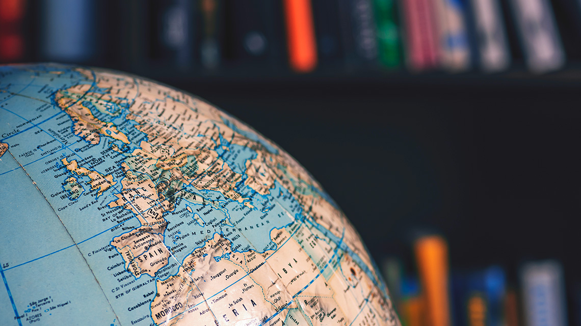
Geography
Geography is the study of the world’s environment, human societies, and human interaction with the environment.
Part of the study of geography is considering both human and physical environments and the ways they interact with each other. This involves learning about the physical processes on and within the planet (physical geography), as well as human activities, cultures, and how people interact and shape places and spaces (human geography).
Boreal Forest, Canada
One example of the interaction between physical and human geography is the Canadian Boreal Forest, in the Canadian Shield. This is a large natural region (physical geography) that is not only important for sustaining wildlife by providing habitat, but also for supporting many communities, such as Indigenous communities. These communities have been in relationship with the natural resources in their traditional territories since time immemorial (human geography). Industrial practices, such as logging and deforestation, affect the land, region, livelihoods of people who depend on it, and the rights of Indigenous Peoples who have stewarded the land for millennia. This demonstrates one of the many ways human and natural systems are interconnected.
Human and physical geography
Take a moment to explore examples of physical and human geography. As you explore the following images in the sorting activity, decide if they can be categorized as:
- human geography
- physical geography
- both, which includes images that show the interaction between the physical land (physical geography), and human activities (human geography)
As you complete the following activity, think about how human and natural systems interact and influence one another. Place the cards into categories that best match. Use the arrow buttons to navigate between cards.
Notebook
Use your notebook to record your thoughts on the following question. If you need some examples, use your preferred search engine to search for examples that demonstrate this interaction.
Can you think of other examples where physical and human geography interact?

Landforms and physiographic regions in Canada
To understand our relationship with the Earth, geographers ask three important questions: What is where? Why is it there? Why care? They may even take it a step further by asking, What now?
Use these geo-inquiry questions to explore landforms and physiographic regions in Canada, helping you understand the spatial significance of these places, and how human and physical systems interact and influence one another.
Definition
Region
A region is a particular area of land that has common features.
Landform regions have similar physical characteristics, such as the type of terrain, or elevation. In Canada, there are the following three types of landform regions:
- lowlands
- highlands
- the Canadian Shield
These landform regions are further broken down into physiographic regions.
Physiographic is a term that is used to describe the processes that have shaped lands through time. The terms physiographic and landform are now used interchangeably. Geologists, geographers, and scientists categorize regions that have similar features such as permafrost, treeline locations, and shape of land into physiographic regions. Permafrost is defined as ground that has stayed frozen for at least two years. In some parts of the country, especially the Arctic, the ground never fully thaws. Treeline is defined as the point where no trees grow at all. Treelines mark the boundary between forests and tundra. The tundra is a treeless region where you find only mosses, shrubs, and grasses.
Exploring the landform regions
In this learning activity, you will be exploring each landform and physiographic region by answering the following questions:
- What is where?
- Why is it there?
- Why care?
Notebook
Review the following document entitled Landform Regions Chart (Opens in a new tab) to complete your notetaking. Organizing your learning into a chart is a useful method when breaking down and simplifying concepts. The notes you make throughout this course, including this activity, will help you complete the culminating assignment.
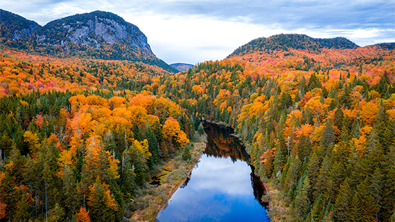
Lowlands
The Thousand Islands region, located in the Great Lakes-St. Lawrence Lowlands region, is characterized by its physical characteristics such as its flat terrain and nutrient rich soil.
Press the following tabs to use the geo-inquiry questions to explore the Lowlands.
Highlands
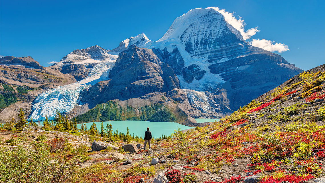
Mount Robson Provincial Park, British Columbia, Canadian Rockies
Press the following tabs to use the geo-inquiry questions to explore the Canadian Rockies.
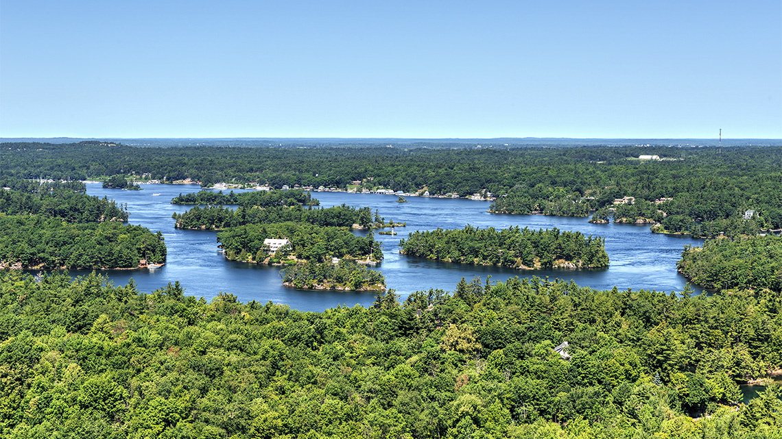
Canadian Shield
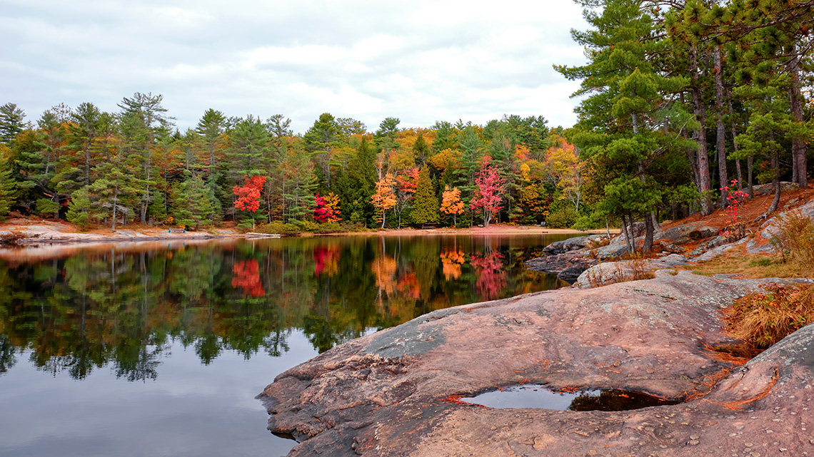
In this image of Silent Lake Provincial Park, in southeastern Ontario, there are physical characteristics typical of the Canadian Shield, such as hard rock formations, granite, lakes, and forests.
Press the following tabs to use the geo-inquiry questions to explore the Canadian Shield.
Note: Update your flowchart with the information you gathered about the landform regions.
When thinking about the ways human and natural systems are interconnected, consider the ways humans might be inspired by nature to create art. In fact, the Canadian Shield was a major source of inspiration for the Group of Seven, a collective of Canadian landscape painters.
Check out the following video entitled Wisdom of the Universe to learn more about Christi Belcourt, a Métis artist, author, and activist from Lac St. Anne, and her piece, “The Wisdom of the Universe” currently on display at the Art Gallery of Ontario.
Notebook
Christi Belcourt shared that, “all species, the lands, the waters are one beating organism that pulses like a heart,” and how this inspires her artwork. To reflect on how humans and geography are interconnected, choose a piece of art (either from your own research or from the video) that you feel connects with a specific landform region in Canada, such as the Highlands, Lowlands, or the Canadian Shield and answer the following questions in your notebook.
- How does understanding the geography behind a piece of art help you see it in a new way?
- How do you think the artist may have been inspired by the landform region’s physical characteristics and landscape?
- How does the artwork show the connection between the land and the people?
Take a break!
Great work!
Now that you have learned about highlands, lowlands, and examined how landform regions in Canada can be displayed through art, it is time to take a break before you use the geo-inquiry process to explore the physiographic regions.
The physiographic regions
As you previously learned, these three landform regions can be further divided into seven physiographic regions, which are regions that have similar physical characteristics.
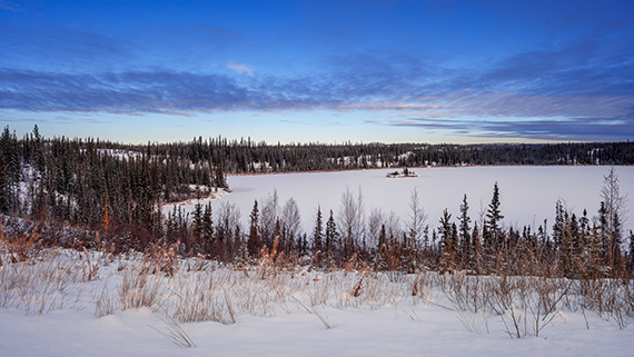
A treeline of Madeline Lake and a small island near Yellowknife in the Northwest Territories, Canada
The criteria for determining these physiographic regions, which are significantly different from one another, are as follows:
- geological structures: this refers to the types of rock (metamorphic, sedimentary, or igneous) and the way these rocks are arranged
- how the permafrost is distributed
- the position of the treeline
Notebook
Examine the following map outlining the physiographic regions in Canada. Then, explore each physiographic region through the lens of the geo-inquiry questions in the following tabs and add your notes to your Landform Regions Chart.

A map of the physiographic regions of Canada.
The Western Cordillera region covers the whole of British Columbia and Alaska and a little of the southwest piece of Alberta and the western part of Yukon Territory.
The Interior Plains region covers most of Northwest Territories, Alberta, and southern Saskatchewan and Manitoba.
The Arctic Lands region covers the northern part of Yukon, the Northwest Territories, and Nunavut.
The Canadian Shield region covers Northern Saskatchewan and Manitoba, the eastern half of Northwest Territories, most of Nunavut and Ontario, Quebec, and Newfoundland and Labrador.
The Hudson Bay Lowlands region covers northeast Manitoba and northern Ontario.
The Great Lakes-St. Lawrence Lowlands region covers the southern tip of Ontario and Quebec.
The Appalachian Region covers a little of the eastern part of Quebec, Prince Edward Island, and Nova Scotia.
Source:
Natural Resources Canada Physiographic Regions of Canada Government of Canada. Retrieved on February 19, 2025, from https://open.canada.ca/data/en/dataset/a3dfbaf4-1b20-4061-aa0a-e7a79953f52d
Press the following tabs to learn more about each of the physiographic regions on the map.
Exploring diverse perspectives
In this learning activity, you used the geo-inquiry questions to explore the physiographic regions in Canada, learning about the ways human and natural systems are interconnected. In doing so, you examined how physical forces, such as glaciation, plate tectonics, and erosion, have shaped the landscape, as well as the human activities that drive Canada’s economy.
Think
Reflect on the following question: How does thawing permafrost impact communities in Northern Ontario?
Coming up
In the next learning activity, you will take a deeper look at one of these physical forces–glaciation–and use the lens of the geographic thinking concepts (spatial significance, patterns and trends, interrelationships, and geographic perspective) to explore how glaciers have shaped the landscape and human geography in Canada.
Connecting to transferable skills
Ontario worked with other provinces in Canada to outline a set of competencies that are important to have to be successful in today’s world. Ontario then developed its Transferable Skills Framework as a set of skills for students to develop over time.
Explore the following video to learn about each of the seven transferable skills.
To learn more about each of the transferable skills, read the following document entitled Transferable Skills Overview (Opens in a new tab) to explore the framework and the descriptors for each skill. Download, print, or copy the information in the document into your notes - you'll refer to it in each unit.
Throughout this course, you will be given the opportunity to reflect on the transferable skills you are developing. Keep your notebook up-to-date and be mindful of opportunities to apply and develop transferable skills.
Self-check quiz
Check your understanding!
Complete the following self-check quiz to determine where you are in your learning and what areas you need to focus on.
This quiz is for feedback only, not part of your grade. You have unlimited attempts on this quiz. Take your time, do your best work, and reflect on any feedback provided.
Press Quiz to access this tool.